Izamal
Izamal is an important archaeological site of the Pre-Columbian Maya civilization. It is the largest town of the Northern Yucatec lowlands, covering an urban extension of 53 square km. Its monumental buildings exceed 1,000,000 cubic meters of constructive volume and at least two raised causeways, known by their Mayan term sacbeh, connect it with other important centers, Ruins of Ake, located 29 km to the west and Kantunil, 18 km to the south, evidencing the religious, political and economic power of this political unit over a territory of more than 5,000 square kilometres (1,900 sq mi) in extension. Izamal developed a particular constructive technique involving use of megalithic carved blocks, with defined architectonical characteristics like rounded corners, projected mouldings and thatched roofs at superstructures, which also appeared in other important urban centers within its hitherland, such as Ake, Uci and Dzilam. The city was founded during the Late Formative Period (750–200 BC) and was continuously occupied until the Spanish Conquest. The most important constructive activity stage spans between Protoclassic (200 BC – 200 AD) and Late Classic (600–800 AD). It was partially abandoned with the rise of Chichen Itza in the Terminal Classic (800–1000 A.D.) until the end of the Precolumbian era, when Izamal was considered a site of pilgrimages in the region, rivaled only by Chichen Itza. Its principal temples were sacred to the creator deity Itzamna and to the Sun god Kinich Ahau.
Five huge Pre-Columbian structures are still easily visible at Izamal (and two from some distance away in all directions). The first is a great pyramid to the Maya Sun god, Kinich Kak Moo (makaw of the solar fire face) with a base covering over 2 acres (8,000 m²) of ground and a volume of some 700,000 cubic meters. Atop this grand base is a pyramid of ten levels. To the south-east lies another great temple, called Itzamatul, and placed at the south of what was a main plaza, another huge building, called Ppap Hol Chak, was partially destroyed with the construction of a Franciscan temple during the 16th century. The south-west side of the plaza is partially limited by another pyramid, the Hun Pik Tok, and in the west lie the remains of the temple known as Kabul, where a great stucco mask still existed on one side as recently as the 1840s, and a drawing of it by Frederich Cahterwood (see our earlier article on his drawings and works) was published by John Lloyd Stephens. All these large man-made mounds probably were built up over several centuries and originally supported city palaces and temples. Other important residential buildings which have been restored and can be visited are Xtul (The Rabbit), Habuc and Chaltun Ha.
Spanish Colonial era
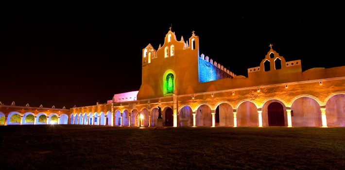
After the Spanish conquest of Yucatan in the 16th century a Spanish colonial city was founded atop the existing Maya one; however it was decided that it would take a prohibitively large amount of work to level these two huge structures and so the Spanish contented themselves with placing a small Catholic temple atop the great pyramid and building a large Franciscan monastery atop the acropolis. It was named after San Antonio de Padua. Completed in 1561, the open atrium of the Monastery is still today second in size only to that of Saint Peter in the Vatican. Most of the cut stone from the Pre-Columbian city was reused to build the Spanish churches, monastery, and surrounding buildings.
Izamal was the first chair of the Bischop of the Yucatan before it was relocated to Merida. The fourth Bishop of Yucatán, Fray Diego de Landa lived here.
For a day trip to Izamal look at our Homun and Izamal day trip section.
Leave a Comment